


🌍 Your Adventure Awaits!
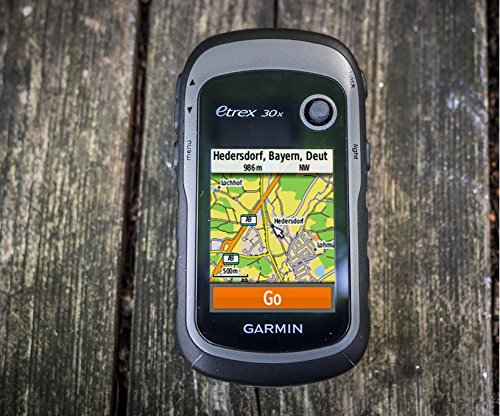
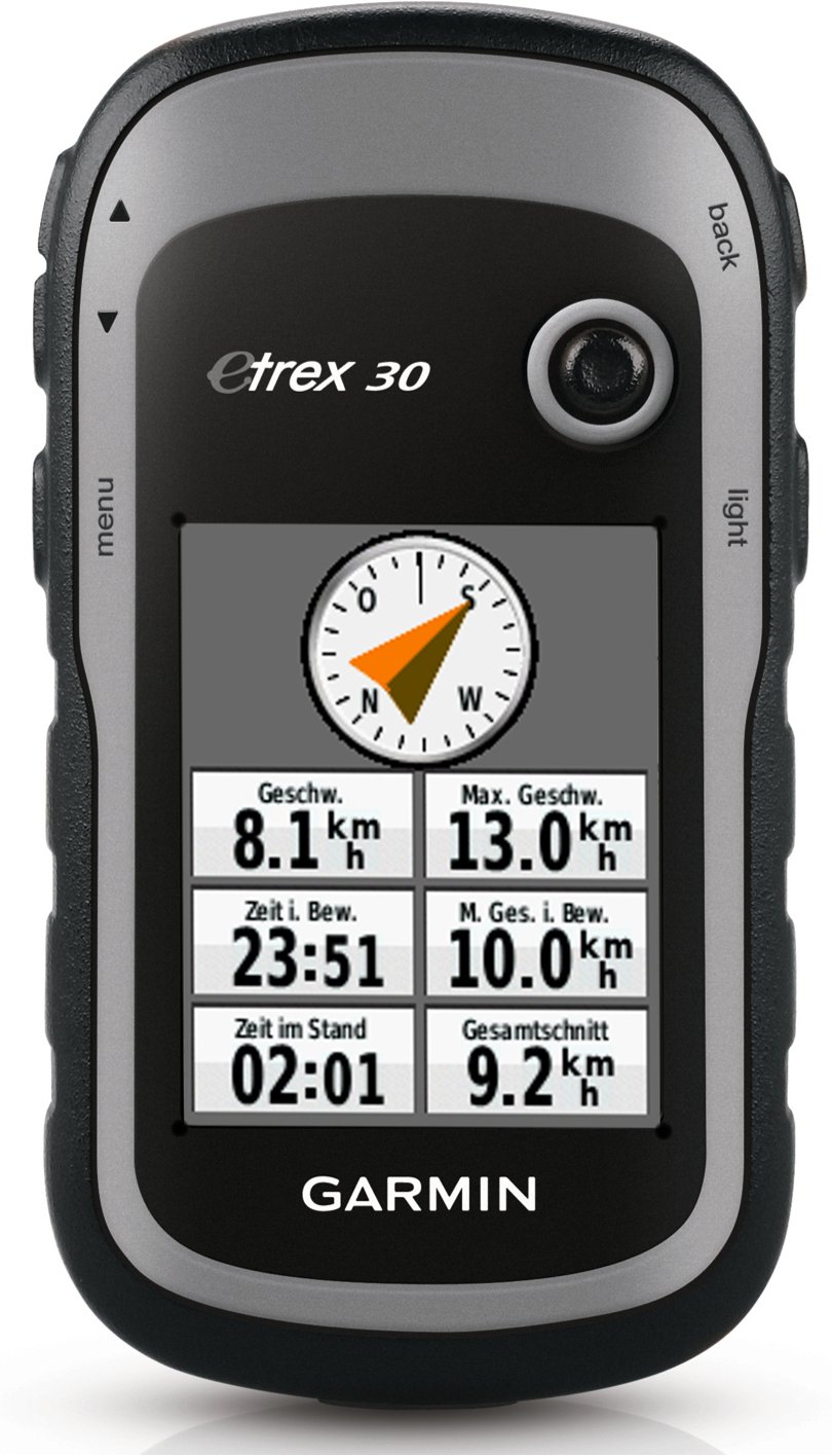
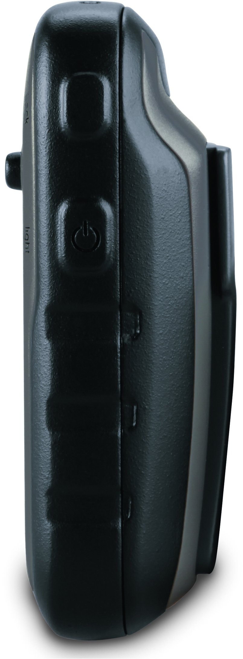
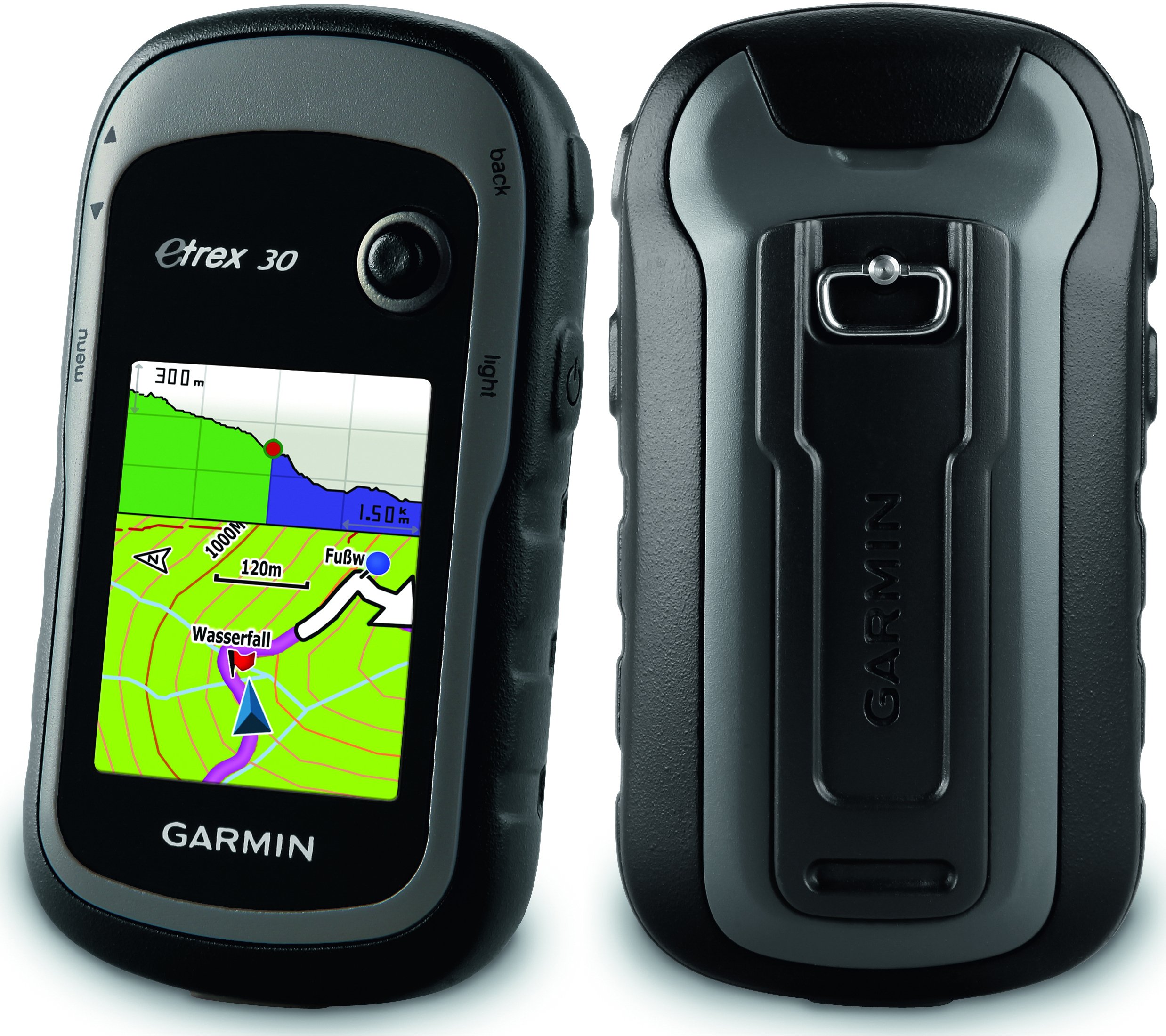
The Garmin eTrex 30 is a robust outdoor handheld GPS unit featuring a 2.2-inch color display, waterproof design, and advanced navigation tools, including a high-sensitivity GPS receiver and support for geocaching. Perfect for outdoor enthusiasts seeking reliable performance in any environment.


| Manufacturer | Garmin |
| Item model number | 010-00970-20 |
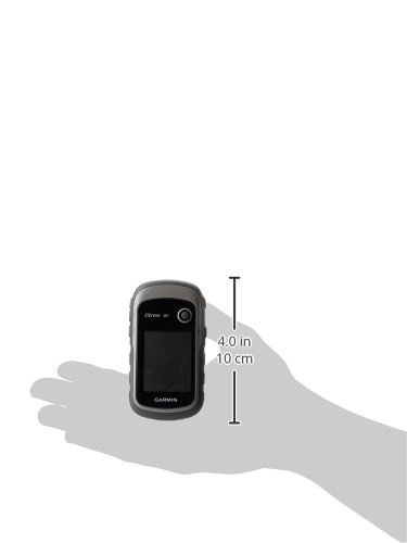
| Product Dimensions | 3.3 x 10.16 x 5.33 cm; 141.75 Grams |
| ASIN | B00542NVS2 |
| Guaranteed software updates until | unknown |
A**M
Durable, solid, perfect for hiking/biking
I am a long time user of other Garmin device - the Forerunner 305.I wanted to upgrade a bit to a device designed more for hiking/biking and eTrex30 is perfect for that!Battery life (left it on for the night on the balcony) was 22h on Energizer 1200mAh NiMh batteries. The screen is quite small but fully functional. Buttons are big and clear, although it is not so easy to operate the device only with one hand. The 4-way joystick works fine, but again with some area for improvement as it works only four ways (up, down, left, right), not possible to go i.e. right-down in one movement.I have used free mtb map of Greece on it, and it is ok for me for the bike use to ride around the city and nearby mountains (the map is detailed enough to cover even minor dirt roads). For hiking unfortunately, I miss the altitude :-/ (I will keep looking for a better one). The accuracy of device is very good (execlent compared to Forerunner), specially in case of the altitude (barometric altimeter works pretty impressive). Compass is also very nice feature!I live in area of low buildings so the device finds satelites in few seconds from turning on! Impressive too!Overall I am very satisfied with the purchase! All specs are percise and work fine for me. I do not find the device slow as one of the reviewers complained - it is fast enough for outdoor usage! (of course I do not have experience with i.e. bird view maps, that might work slower...)
D**R
Very useful and helps to take out the guesswork.
I really do like my etrex30. Carrying this I can always tell where I am and see a local map, which makes it easy to work out which way to go. Even on simple walks in a new area it is easy to decide whether to go right or left at a fork, and saves the extra miles needed to get back to a recognisable landmark. I have also used it to find my way around London streets, but it is too small to use while driving, so you need a navigator in a car. For the health concious it also tells you how long, far, and fast you have walked, climbed and descended, as well as how long you stopped. Detailed analysis is possible on the built-in track analyser but easier to see and edit on Basecamp, free Garmin software. I have installed a microSD card and find it best to store individual tracks on it. It is then worthwhile to reset all track data at the start of a walk so eack track is specific. Before doing this I accumulated several hundred miles of walk, boat and car track across Ireland, Scotland and England, which made it a bit more difficult to find the bits iI wanted. I was able to take out the walks and make individual tracks using Basecamp. I use free maps and have Freizeitekarte_GBR and Freizeitekarte_IRL enabled. This is only because these were the ones Garmin map installer software preferred. I have loaded OSM street map too. One thing to watch, when it is switched on it starts recording, so the best way to track individual events is to switch it off between events. Switch it on and let it find sattelites then reset current track as you start your adventure. It will have your position leaping around as it firsts detects individual sattelites, and you really will need to delete that. Once fixed it will detect you crossing from side to side in a narrow lane. It gets a bit jittery in a broadleaved forest but keeps the track to withing a few metres, correcting itself as you move along. If you switch it off while travelling then switch it on without resetting the current track it draws a straight line from the last known point to the current one.You do need to read the instructions and play with it to get the best from it, although you can track yourself well enough just using reset between walks and viewing the trip computer to monitor progress. Having said all this, it is still a good idea to have a look at the whole route on a map before you start, and in some terrains and weather your life may depend on it. If I was in a snowy white-out, or pitch darkness, then I would prefer the etrex to a map and compass. Even well signposted walks sometimes fail at cross-paths in the middle of featureless woods or heaths.
M**E
Excellent gps with basic maps only.
I own an etrex VENTURE HC,and was asked by our walking club to purchase two gps's for club use. I chose this one for its features and increased memory,and set it up for the club. Irish maps were loaded from a source which provides free Ireland maps as the club did not entertain the thought of buying exhorbitantly priced maps from Garmin.I have used this gps a few times and observations are,relative to my own etrex Venture HC:1.Easily set up.2.Buttons are more responsive with a firmer feel.3.More easily negotiated menus.4.Brighter display.5.Excellent in the field-but I have a feeling(only a feeling) that it may not be just as sensitive in wooded areas as the VENTURE HC.6.Batteries seem to last longer.All in all, a top class and responsive gps-pity they wouldn't include better maps for walkers.
S**M
Great GPS
This is a great GPS that has served me very well in a few places around the world. It's small, easy to operate, waterproof and rugged. It comes with 1.7gb of memory but i would strongly recommend purchasing a MicroSD card of class 10 speed (if Sandisk then its the 'ultra' model) the size just depends on how many maps you will store on there. Speaking of Maps it's important to remember that the map supplied with the GPS is very basic and borderline useless outside of main roads and motorways. The official Garmin maps are ridiculously expensive, fortunately Garmin let you use custom maps (other brands do not) and if you look around on the internet you can find websites that will give you maps for free or for a small price (TalkyToaster, GPSFileDepot, MapasAlternativas etc). You will probably want to visit Garmin's website to install important software updates and also download their mapping programs such as Garmin BaseCamp.All in all there is a bit of hassle setting everything up and don't be surprised spending a day or two to set it up but once it's all setup and updated etc it really does it job well!
R**E
C’est tres bien
Chasse
R**A
Five Stars
Exlent working
A**N
Great for hiking with free maps/tracks
I've been using the GPS on my phone for hiking and backpacking for a couple years now. The EveryTrail app is terrific. That said, the phone battery only lasts about 4 hours when used constantly as a GPS, and after hiking with other people using Garmins, I finally bought this Etrex 30. It's light (4.5 ounces with battery), lasts MUCH longer than my phone, and works much better as a GPS. I can now leave my phone off and save the battery. (It's also much easier to read in bright light than my phone is, and unlike my phone, can be easily viewed using polarized sunglasses.)There's a lot of negative comments and reviews here, though, which I'm glad I ignored.No, maps don't come with this unit, but they are easily available for free online at gpsfiledepot.com, good-quality maps with installation tutorials. I fit a topo of California plus two separate overlays of hiking trails into the built-in storage, and I've still got over 1 GB of space left. A microSD slot is available for people who need still more space. You can also find GPX tracks for free on the web which can be transferred to the GPS. EveryTrail, for example, has many high-quality hiking tracks which can be saved as GPX files (from the EveryTrail web site) and then transferred to the GPS using Garmin's BaseCamp software. This is actually now my preferred method of getting trails onto the GPS, with the free California topo as a background.Yes, the instructions are poor to nonexistent, but the menus aren't that hard to figure out if you've used a GPS in some other form. Just walk through the menus and play with it a little. Some default functionality is annoying, but every problem I've had so far was fixable through a setting. (For example, I didn't see place names until I changed the maps settings, and I have no need for constant backlighting, which just drains the battery. The default track color is very hard to read against a topo background, so I changed the color to red.)I agree that they could have included a lanyard, and there's no clip with this thing. For now I carry it in my shirt pocket, but I'll probably attach a carabiner and a cable tie to the lanyard attachment point to make sure it doesn't get lost.This is my first standalone GPS, and I'll probably be figuring more stuff out over time, but given the weight and battery life and accuracy and wealth of free maps, I'm quite satisfied. It's much more reliable than using my phone.
F**E
excellent gps de rando
Bonne autonomie, précis (mode glonass), lisible même en plein soleil.Mais indications de distance et de dénivelée assez fantaisistes, malgré une mise à jour du logiciel.L'analyse de la trace une fois à la maison nous donne des meilleures indications.Le tracé enregistré est précis, sauf dans des conditions difficiles (fond de vallée, falaises). Précision de l'ordre de quelques mètres (et souvent mieux, le tracé colle de très près à la photo aérienne).Le compas et le baromètre sont un plus.Précision altimétrique pas mal (grâce au baromètre).
A**A
Pratico e resistente
Lo ho proferito ad altri modelli più recenti per la mancanza dello schermo touch, che a mio avviso per uso mtb e trekking (con guanti) non è indicato. Facilmente utilizzabile ed aggiornabile (io ho caricato le mappe OpenStreetMap - OSM) e funziona benissimo. Pratica anche l'alimentazione: usa pile stilo ricaricabili o in mancanza normali stilo AA, senza necessità di portarsi dietro alimentatori specifici. Come sottolineato in altri feedback, lento nel caricamento dati da pc x la presenza di porta USB tradizionale, ma sono poche le volte che lo collego (aggiornamento mappe). Resistentissimo: mi è caduto un paio di volte e nessun problema. Veloce anche ad agganciare il segnale GPS.Lo consiglio per la leggerezza, la resistenza e la durata della batteria (disattivate la retroilluminazione qnd non serve, effettivamente consuma molta batteria). Per chi lo usa in bici, attenzione al fissaggio sulla staffa dedicata, se non si incastra fino in fondo al primo salto, vola via.Ottimo feed anche per il venditore: veloce e corretto: mi ha addirittura contattato via fono perchè il corriere non riusciva a trovare il luogo di consegna.
Trustpilot
1 month ago
1 month ago
